- Pagina iniziale /
- Libri /
- Science & Math /
- Earth Sciences /
- Geography /
- Historic /
- Maps, Annotated: The World's 300 Greatest Map...
0 ratings






Articolo #:
181845282
Maps, Annotated: The World's 300 Greatest Maps Explained
89% degli intervistati lo consiglierebbe a un amico
Articolo #:
181845282
€ 50
Dettagli del prezzo
Escluse spese di spedizione e doganali ( Le spese di spedizione e doganali saranno calcolate al momento del pagamento )
*Tutti gli articoli verranno importati da Stati Uniti
0 ratings
Scrivi una recensione
Disponibile
 Importato dal negozio USA
Qtà:
Ordina subito e ricevilo entro Giovedì, Ottobre 15
Transazione sicura
Ubuy works hard to protect your security and privacy. Our advanced payment security system ensures confidentiality by encrypting your information during transmission using AES (Advanced Encryption Standards) and SSL (Secure Socket Layer) protocols. Your payment details are 100% secure as we do not share your payment details with third party sellers.
I nostri principali partner logistici


Immerse yourself in the most intriguing maps ever created with Maps, Annotated.

Consegna
veloce

Reso
gratuito*

Imballaggio sicuro

Prodotti originali al 100%

Conformità PCI DSS

Certificazione ISO 27001



Note: Step Down Voltage Transformer required for using electronics products of Stati Uniti store (110-120). Recommended power converters Acquista ora.


Cosa salta all'occhio
Comprehensive Coverage
Explore 300 of the most significant maps in history, providing readers with a rich visual and historical narrative that enhances understanding and appreciation of cartography.
Expert Insights
Each map is thoroughly explained by experts, offering unique perspectives that illuminate their cultural, historical, and geographical importance, making it a valuable resource for enthusiasts and scholars alike.
Visual Quality
The book features high-quality reproductions of maps, allowing readers to appreciate intricate details, colors, and craftsmanship, making it both an educational tool and a visually stunning coffee table book.
Dettagli del prodotto
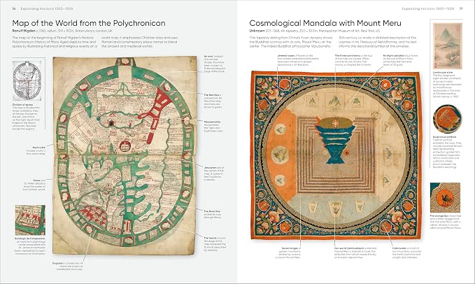
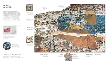
- This fascinating history of cartography includes more than 300 maps, from the ancient world to the present day.Combining stunning reproductions with clear annotations and pull-out details, it is an expertly curated selection of the finest examples ever created.Delve into Maps, Annotated and find out how the Polynesians used sticks to chart their way across the Pacific, what a meridian is, and where dragons were said to lurk. Discover ancient Chinese star maps, decipher medieval Mappa Mundi, and find out how the world is split into time zones. Organized chronologically, the book features maps from all over the world, explaining key elements such as compasses, scales, symbols, and geographic features. Each map is also set in historical context, making Maps, Annotated a complete overview of the history of cartography.From Babylonian world maps to the Aztec map of Tenochtitlán and the Gaia map of the Milky Way, immerse yourself in the most intriguing maps ever created. Comprehensive and lavishly illustrated, Maps, Annotated is a must for all armchair explorers.
| Publisher | DK |
| Publication date | October 21, 2025 |
| Language | English |
| Print length | 480 pages |
| ISBN-13 | 979-8217126316 |
| Item Weight | 5.3 pounds (2.4 kg) |
| Dimensions | 9.63 x 1.4 x 11.38 inches (24.5 x 3.6 x 28.9 cm) |
| Part of series | DK Annotated |
A chi è consigliato?

-
History Enthusiasts
Individuals interested in historical events and their geographical context will appreciate the detailed explanations of each map.
-
Students and Educators
Suitable for students needing visual aids in geography and history classes, enhancing their understanding of cartography.
-
Travel Buffs
Travel enthusiasts will find joy in exploring maps that highlight historical travel routes and significant landmarks worldwide.

-
Casual Readers
People looking for light reading material may find the detailed map analysis overwhelming or uninteresting.
DESCRIZIONE DEL PRODOTTO
Hai qualche domanda? chatta con noi
Domande e risposte dei clienti
-
Domanda:
Come acquistare Maps, Annotated: The World's 300 Greatest Maps online da Ubuy?
Risposta: È facile acquistare Maps, Annotated: The World's 300 Greatest Maps online da Ubuy.. Devi solo cercare il prodotto, scegliere il metodo di spedizione durante il check-out e farlo consegnare alla tua posizione. -
Domanda:
Maps, Annotated: The World's 300 Greatest Maps è disponibile per gli acquisti online in San Marino?
Risposta: Sì, su Ubuy San Marino questo prodotto è disponibile per gli acquisti a un prezzo ragionevole.. Il Maps, Annotated: The World's 300 Greatest Maps non è disponibile localmente ma puoi fidarti di noi con i nostri servizi di spedizione espressa. -
Domanda:
Quanto tempo ci vuole per ottenere il prodotto dopo aver effettuato l'ordine?
Risposta: I tempi di consegna del prodotto ordinato variano in base a ciò che hai ordinato e al metodo di spedizione che hai scelto.. Il tempo di consegna stimato viene menzionato durante il processo di pagamento, quindi sii spensierato durante lo shopping.
Historic Editorial Review
Maps, Annotated: The World's 300 Greatest Maps Explained offers an in-depth exploration of historical and contemporary cartography. With a substantial print length of 480 pages, this book is published by DK and is set for release on October 21, 2025. It's penned in English and features high-quality imagery and explanations of maps that have shaped our understanding of geography. As part of the DK Annotated series, it is designed for enthusiasts of maps and history alike, making it a valuable addition to any collection. Readers can expect a captivating journey through the art and science of mapping with this comprehensive guide.
Recensioni e valutazioni dei clienti
11 valutazioni dei clienti
-
5 stella
75%
-
4 stella
0%
-
3 stella
12%
-
2 stella
0%
-
1 stella
13%
Recensisci questo prodotto
Condividi le tue impressioni con altri clienti
Vantaggi
- High-quality imagery and detailed explanations
- Comprehensive content for map enthusiasts
- Substantial length for in-depth exploration
- Published by a reputable publisher
- Well-structured for easy navigation
Contro
- May be heavy for casual readers
Customers also viewed these products
Cronologia dei prezzi del prodotto
Informazioni importanti
- Limitazioni: per i prodotti spediti a livello internazionale, si prega di notare che ogni garanzia del produttore potrebbe non essere valida, le opzioni di assistenza del produttore potrebbero non essere disponibili, i manuali del prodotto, le istruzioni e gli avvisi di sicurezza potrebbero non essere nella lingua del paese di destinazione. I prodotti (e i materiali di accompagnamento) potrebbero non essere progettati in conformità con gli standard, le specifiche e i requisiti di etichettatura del paese di destinazione e i prodotti potrebbero non essere conformi alla tensione di rete del paese di destinazione e ad altri standard elettrici (richiedendo l'uso di un adattatore o di un trasformatore, se necessario). Il destinatario è responsabile di assicurare che il prodotto possa essere legalmente importato nel paese di destinazione. Quando si ordina da Ubuy o dai suoi affiliati, il destinatario è l'importatore registrato ed è tenuto a rispettare tutte le leggi e i regolamenti del paese di destinazione.
- Non tutti i prodotti elencati su Ubuy sono in vendita, poiché Ubuy è un motore di ricerca globale. I prodotti sono soggetti a regolamenti di esportazione/commercio.
€ 50
Ordina subito e ricevilo entro Giovedì, Ottobre 15
Questo articolo non è vietato nel mio Paese. (Se l'articolo non è vietato nel tuo Paese, fai clic sul link: il nostro team verificherà l'autorizzazione.)
Qtà:
Transazione sicura
Conforme allo standard PCI DSS e certificato ISO 27001:2022, con pagamenti crittografati e piena protezione dell'acquirente su ogni ordine.
I nostri principali partner logistici
Consegna transfrontaliera più rapida
Caratteristiche e benefici
- Over 300 stunning maps from ancient to modern times.
- Expertly curated with clear annotations and details.
- Covers key mapping techniques like compasses, scales, and symbols.
- Organized chronologically to showcase the evolution of cartography.
- Includes fascinating historical context for each map.
- Perfect for enthusiasts and armchair explorers alike.
Garanzia Ubuy
Vivi un'esperienza di shopping senza pensieri con prodotti 100% originali, sicurezza dei pagamenti conforme allo standard PCI DSS, protezione dei dati certificata ISO 27001, la consegna internazionale più rapida, resi gratuiti, e imballaggio sicuro su ogni ordine.*